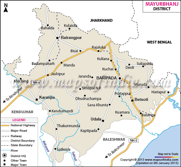
Map of Myurbhanj
 * Mayurbhanj District Map highlights National Highways, Major Roads, District Headquarter, etc.
Mayurbhanj, with a total area 10,418 sq km, has four sub-divisions.The district has a total population of 22,23,456 of which males have a share of 11,23,200 and females have 11,00,256 (census 2001). The literacy rate of the place is 52. 43%.
Equipped with a total cultivable land of 4,47,214 hectares, Mayurbhanj is known for a high growth of paddy. Apart from a rich reserve of mineral resources, the district generates income through three industrial estates.
The stunning Kichakeswari and Rasikaraya temples, Deokund and Bhimkund enhance the tourism scenario of Mayurbhanj.
Covering a total geographical area of 10,418 Square Kilometers, Mayurbhanj is a district of Odisha. The land locked district of Mayurbhanj is located at the Northern extreme of the state of Orissa and Baripada is the headquarter of the district. Lying at a Longitude of 85 degree 40' and 87degree11' East and a Latitude of 21degree 16' and 22 degree 34' North, the Mayurbhanj district is bordered by the Keonjhar district in the East, Midnapore district in the North, Singbhum district in the South and the Balasore district in the West.
The topography of Mayurbhanj district is marked by hills and undulating plains. The most dominant feature of the topography of the Mayurbhanj district is the Simlipal Range which cover the very center of the district. The geography of Mayurbhanj can be divided into three natural divisions. The hill ranges that are located at the very center of the district divide the region into two halves, Western and Eastern. The Eastern part is made up of fertile slopes that stretch from the foot hills to the sea. The Western part is mainly made up of plain lands with gentle slopes and rocky hills.
The mayurbhaj district is picturesque and there are a number of tourist spots in the region. The most popular tourist attractions in Mayurbhanj include:
- Khiching
- Kuchai
- Manatri
- Haripur
- Bhimkund
- Simla
- Similipal
- Deokund
- Devagram
- Lulung
- Badasahi